
Cold Air Damming Sunday for North Carolina
Cold air damming or cold air wedging is something people of the Carolinas are very familiar with. It’s a weather phenomenon we get more than any other part of the country. It’s a function of our geography and topography being sandwiched between the Appalachian mountains and the Atlantic ocean. This is why we get so many ice storms around here, though we have been extremely lucky over the past few winters. Even without ice or the dreaded wintry mix the CAD(cold air damming) can bring sometime. It can still have large impacts on our weather.
This weekend is a great example. The CAD is going to make for a cold, cloudy and dreary weekend for some and for others a warm and stormy weekend. It all depends on location either south of the CAD boundary or North.
Lets take a look at the typical CAD set-up.
(Credit http://www.martinsvilleweather.com/content/learn.html)


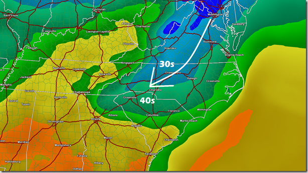
The set-up this weekend from the model guidance Sunday:
First lets looks at the sounding from the GFS model. This is a cross section of the model data displaying the 2 meter temperatures in the red line and dew points the green line. You read this from right to left where the left is the current time and to the right which is in the future. The colors are moisture or clouds in this case and the green bars are hourly rain totals.You notice the the up and down swings from highs to lows each day. Except for Sunday at 2pm when you should have a peak notice you actually have a dip, another true sign of the CAD. Yellow arrows are the highs Saturday and Monday but notice the blue arrow for Sunday’s high, which isn’t so high.

NAM
This is looking at a map display of the CAD setting up Sunday from the 2 main American models.

GFS

The results of this CAD and some moisture overrunning it will be chilly, cloudy and wet conditions Sunday. Where the cold air is deeper we might see a light wintry mix. That right now seems confined to areas closer to the Yadkin Valley and areas north of the Triad near the VA border. Not expecting this to be a big problem due to the very light nature of the precipitation and the very warm ground temperatures. Here’s a look at the precipitation types from the models.
NAM
Red is freezing rain and green is just rain

GFS


