
Last Weeks Downbursts & Arcus Clouds
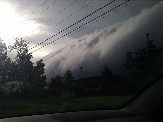
Last Thursday our entire area was impacted by a severe line of severe thunderstorms. These storms carried damaging winds of between 60 to at times 100 mph causing widespread tree and power line damage. Now many people have never seen shelf clouds or arcus clouds which often accompany these types of storms. There are particular prevalent when you have such hot and humid air ahead of a line of storms like we had last Thursday. These scary looking clouds are not tornadoes at all, but are a sign of very strong outflow winds.

I wrote a blog post about “scary looking” clouds that are often confused with tornadoes. The problem with the confusion is people always think it has to be a tornado to cause damage which could not be further from the truth. You are 10 times more likely to be impacted by a damaging straight line wind than a tornado. This is also why I shy away from using the term Derecho because we don’t know if a storm system was truly a Derecho until after the fact. Plus there are plenty of damaging windstorms that aren’t even close to a Derecho by definition. The simple fact is trees, power lines, mobiles home and other structure will sustain damage at 60-100mph winds regardless of what causes that wind. Once again focusing on the impacts are far more important that what it’s called and also why severe thunderstorm warnings should be taken seriously.
Last Thursday:

There were 2 particular areas that had a heighten damaged path from a downburst or microburst. Those 2 areas were along I-40 and another from Cabarrus County into Stanly and Montgomery Co.


The National Weather Service confirmed the damage in hard hit Albemarle as a Microburst. Some people are still without power today.
What caused this?


I’ve heard the term downburst and microburst…what’s the difference?
- A downburst is a strong downdraft which causes damaging winds on or near the ground.
- The term “microburst” describes the size of the downburst.
A comparison of a microburst and the larger macro burst shows that both can cause extreme winds.
Microburst
Damaging winds extending 2 1/2 miles or less
Lasts 5 to 15 minutes
Can cause damaging winds as high as 168 MPH!
Macroburst
Damaging winds extending more than 2 1/2 miles
lasting 5 to 30 minutes
Damaging winds, causing widespread, tornado-like damage, could be as high as 134 MPH!
How do downbursts happen?

FAA Image
Cold air begins to descend from the middle and upper levels of a thunderstorm (falling at speeds of less than 20 miles an hour) As the colder air strikes the Earth’s surface, it begins to “roll” – much like water as a boat moves through it. As the colder air “rolls” out, it is compressed causing winds to increase dramatically – at times even stronger than tornado winds!
How are downbursts different from tornadoes?

Graphic by T. Fujita
Downburst
The key difference is in two words – IN and OUT!
IN – all wind flows INTO a tornado. Debris is often laying at angles due to the curving of the inflow winds
OUT – all wind flows OUT from a downburst. Debris is often laying in straight lines (hence the term “straight line winds”) parallel to the outward wind flow
How frequently do downbursts occur?
Downbursts are much more frequent than tornadoes – in fact, for every 1 tornado there are approximately 10 downburst damage reports!
Tornadoes
Average of 1200 per year in the U.S.
Thunderstorms
Average of 100,000 per year in the U.S.
What visual clues should I look for with downbursts?
This series of photographs shows a microburst picking up dust and dirt – making the “roll” very easy to identify
Unfortunately, you can’t look at a thunderstorm and “see” if it’s going to be severe. Doppler radar is able to “look” inside the thunderstorms and “see” the movement of air – giving the meteorologist indications of microbursts and allowing them to issue warnings.
Why downbursts are often mistaken for tornadoes
- Both can have very damaging winds
- Tornado winds range from 40 to over 300 MPH. Downburst winds can exceed 165 MPH
- A loud “roaring” sound
- Wind speeds of 75+ MPH will often sound very load – leading some to believe they heard a tornado when if fact they only heard a straight-line wind
- Trees were “twisted” off – so it must have been a tornado
- This is one of the most common mistakes – the fact that trees were “twisted” off doesn’t necessarily mean a tornado has gone through. If you could draw a line straight down a tree, you’d see that the tree isn’t exactly alike from one side to the other. Differences in limbs and leaves may cause the tree to have more wind resistance on one side than the other. The tree begins to “twist” (much like a stop sign “twists” in strong winds), if wind speeds are high enough the tree will begin to tear apart in a twisting motion -even though the winds are relatively straight!
The best way to determine if damage was caused by a tornado or a downburst is to fly over the area and look down on the damage path.
(Credit NWSFO Columbia, SC)


")

