Is 2012 The Year of Large Hail?
There’s little doubt that last year 2011 was know among meteorologists and the public as the year of the tornado. Mainly because of the number of tornadoes but also the extreme death tolls driven by large outbreaks in April and May. This year I have noticed a different trend in the severe weather numbers. Hail!
The amount of hail reports this year so far exceeds the number of wind and tornadoes reports compared to the 6 year running average. Now you would always expect there to be more wind and hail reports than tornadoes. In this case I’m looking at just the comparison to average.
Take a look at the daily count of 1” hail or larger reports sent in to SPC. Through April 30th the number was 2464 when the running average should be around 1686.
Now look at the tornado reports compared to the 6 year average.
Now here are wind reports.
Last year all severe weather number ended well above the 6 year running average. Which is expected due to the shear number of severe thunderstorms that occurred. You would expect a large number of supercells or rotating thunderstorms to not only produce tornadoes but many reports of large hail. So what’s going on this year? I’m not entirely sure but it would seem that hail storms just seem to be the main storm type this year. Maybe we have had lots of non-tornadic supercells with large hail. Or could it be a reporting anomaly? Could it be the change to the 1” hail criteria.? (Already asked Patrick Marsh about this one)
My theory
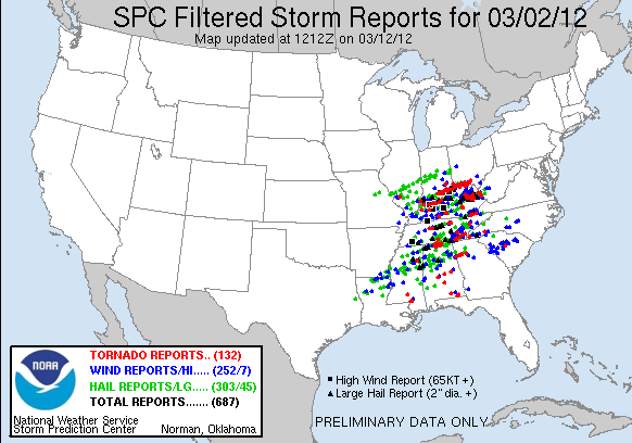
I want to look at more data to see if this is just a random occurrence but I do theorize if the warm March was a contributing factor? On one outbreak alone the March 2nd tornado outbreak we also had over 300 reports of large hail on this day. The whole month of March had 1146 hail reports for the entire month, by far the most of any month this year. 
Record Heat:
March was also a record breaking month for warm temperatures. One thing about warm weather in March is the mid and upper levels of the atmosphere are still cool. So while there was intense surface warmth this could have contributed to strong updrafts into a very low freezing level. Or it could just be an oddity, but it has me thinking.
Still looking for answers…


