Rock Hill Tornado
Looking back at the radar data from Frist Warn Doppler. I was able to see where the circulation on radar compared to the damage I was able to survey first hand. The circulation was much stronger looking back in Laurens and Union county then in Chester and York Co.
The fact that the circulation was so well defined back in those counties and trained spotters reported a touchdown made me watch this cell very closely. The tornado warning was well placed and we tracked it exactly where the damaged occurred. Even so the signature was anything but “textbook” on radar. Here’s a look at the volume scans that show the initial touchdown and then the lifting of the tornado. Which ended up being a blessing because as bad as the damage and lose of life was. It could have been worse if the tornado stayed on the ground into the highly populated areas around downtown Rock Hill, Fort Mill and into Pineville and Ballantyne
Here’s a look at the radar from that evening:
5:38pm
Below are the reflectivity(left) and radial velocity(right) from the Terminal Doppler radar near Mountain Island Lake. You can see the hook echo and a small velocity couplet but we were getting some serious aliasing of the radar beam. That’s the purple area in the image on the right.
5:44pm
This is when the tornado was causing EF-2 damage near HWY 324 and Williamson road. In fact the tip of the arrow is pointing to that exact intersection.
5:50pm
This when the tornado thankfully lifted but you can still see circulation within the storm.
Here was the tornado track and the worst damage plotted on Google Earth.
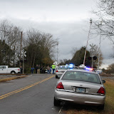
These are the pictures I took from the ground.
 |
| November 17, 2011 Rock Hill Tornado |
Before and after Pictures.
NASA’s TRMM Satellite Sees Deadly Tornadic Thunderstorms in Southeastern U.S.


