
Big Pattern Change On the Way
The winter has been off to a very mild start but mid January into February we might be seeing some major changes. Almost as if on cue mother nature looks to be turning much colder. I should note that historically January 7th through the 16th has the coldest average temperatures here in Charlotte. When the average high is 50° and the average low is 29°.
One of the two short range climate predictors I look at for cold weather are starting to god negative. The first teleconnection we call the Arctic Oscillation. When that index goes negative it forces warm air south from the Arctic.
NASA defines the AO below:
The Arctic Oscillation is a climate pattern that influences winter weather in the Northern Hemisphere. It is defined by the pressure difference between air at mid-latitudes (around 45 degrees North, about the latitude of Montreal, Canada or Bordeaux, France) and air over the Arctic. A low-pressure air mass usually dominates the Arctic, and while higher pressure air sits over the mid-latitudes. This pressure difference generates winds that confine extremely cold air to the Arctic. Sometimes, the pressure systems weaken, decreasing the pressure difference between the Arctic and midlatitudes and allowing chilly Arctic air to slide south while warmer air creeps north. A weaker-than-normal Arctic Oscillation is said to be negative. When the pressure systems are strong, the Arctic Oscillation is positive
Arctic Oscillation Phases and their impact on weather:

Remember how cold it was last winter? This was because of very negative phase of the Arctic oscillation. This causes warming in the arctic and major cooling in the mid-latitudes.

Here’s the forecasted for the Arctic Oscillation:
Notice all the GFS model runs show the AO going negative. Notice how low some of the runs go after they jump briefly going into this weekend.

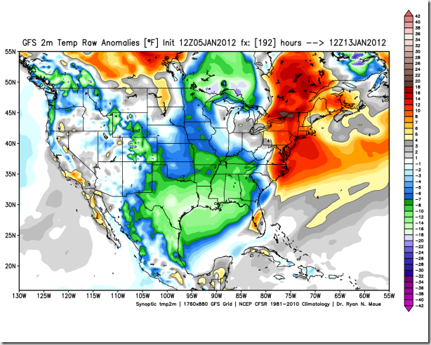
The resulting GFS temperature anomalies show major cooling in the lower 48 states going into late next weekend. Those green colors are temperatures 8-18° below average for this time of the year at the surface.

Below is a look at the 850mb temperature for the 14th. These are the temperatures at about 5,000’. Either way you slice it things will be getting much colder starting late next week.

There are signs the NAO or North Atlantic Oscillation maybe going down slight as well. Not as much as the AO but any downward trend just confirms that things are trending colder over the next few week.
(All images credit of Dr. Ryan Maue http://policlimate.com/weather/)


