White Christmas Chances for Charlotte Increasing
Well we are only 4 days away from Christmas and the weather guidance is starting to come into focus much better. Even though the trends have been both wetter and colder for the piedmont of the Carolinas. There are still many finer details like amounts and timing that need another day or two to come into focus. Before you can talk about snow on Christmas Day in Charlotte you have to look at the very short history of that actually happening. The last time it happen was in 1947 and that’s also the most snowfall we have ever seen on Christmas Day 5.8”. Here’s a look back at some Christmas Day weather history for Charlotte.
CHRISTMAS WEATHER HISTORY | ||||||
| CHARLOTTE, NC | 1878 | 2009 | ||||
| SNOWFALL | YEAR | |||||
| 5.8” | 1947 | |||||
| 4.0” | 1880 | |||||
| 0.2” | 1909 | |||||
| T | 1899 | |||||
| T | 1953 | |||||
| T | 1962 | |||||
| T | 1969 | |||||
| T | 1975 | |||||
| T | 1993 | |||||
| T | 1998 | |||||
As you can tell it doesn’t happen very often around these parts in fact based on this data it’s only happen 2.2% of the time in 132 years of records. It should be noted though we have had some trace amounts of sleet and snow on Christmas day. Basically this is when some flakes or sleet pellets were in the air but didn’t accumulate and that has happened as recently as 2007.
Christmas 2010 forecast 4 days out
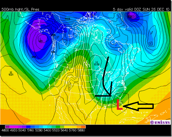
Right now there are 2 of the 3 major long range models pointing to a southern storm track for our Christmas storm. Which means colder air will be able to overspread the Carolinas. They also show a strong dynamic system with plenty of moisture to bring accumulating snow to the region. The EURO model shows a very strong low pressure system moving over northern Florida and up the Carolina coast Saturday night through Sunday morning. While this is the strongest of the 3 models it’s also the slowest and might mean more snow overnight Saturday into Sunday. So maybe more of a white day after Christmas.
European model Saturday evening
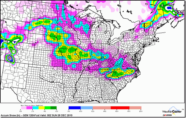
Then you start to look at the GEM model which actually has a snow product it puts out and remember this is way early. These types of details won’t be better understood under 48 hours out so take this with a LARGE grain of salt.
GEM model snowfall forecast through Saturday evening
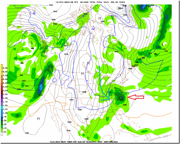
Then we take a look at the GFS model. It’s the one model that is much further north than the other 2 and takes the low right over us with mostly rain then some snow at the end. It should be noted though that even the GFS has been trending further south than previous runs. Just 2 days ago it had the low tracking closer to the Ohio Valley so it’s shifting south too just not as much as the other two.
GFS model for Saturday night
Now the fine print
While all of this is very exciting it’s still 4 days out and experience tells me that forecasting snow in he Carolinas is very hard 24 hours out let alone 96 hours out. This storm is still over the pacific ocean and and should be over California later today. This is important to note because wile the U.S has great weather data the rest of world is lacking especially over the Oceans. There are huge data voids over the oceans where we have to rely on satellites mainly. Forecast models are only as good as the data you put into them. So it’s likely these model forecasts of this storm have had very limited data actually put into them. Once the storm is over North America the model will be loaded up with bigger and better data. (BTW this is why hurricane forecasting is so hard and why they fly the hurricane hunters into those storms) So time will tell and I think Wednesday is a key day for knowing if we should move the Snowmeter from water cooler talk to bread and milk. Or should it be milk and cookies this weekend? ![]()
Stay Tuned forecast confidence is just 40% right now.


