

What El Nino could mean for Charlotte this winter.
So by now we have all seen the headlines about the strong El Nino that is building. Most people probably aren’t entirely sure what El Nino is let alone what a “Godzilla” El Nino means. (Side not I hate headlines like that). So let’s talk about what El Nino actually is and what it could mean for the upcoming winter here in the Southeast.
What is El Nino?
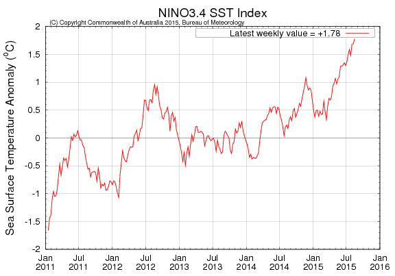
It’s the warming of the equatorial Pacific water between South America and Australia. Once the area known as El Nino 3.4 maintains an above average sea-surface temperature SST of 0.5° C or higher for 3 consecutive months, we considered it an El Nino.


So what does that mean?
This warming of the waters in the Pacific sets off a chain reaction in the atmosphere above it. Which causes the trade winds to relax and forces the subtropical jet stream to become more active over the Southern U.S.

This causes a seasonal pattern change over the U.S. during the cool season from late Autumn through Winter and into early Spring. This active southern jet stream brings more storms into Southern California from the Pacific and across the Southern U.S. into the Carolinas on average.
El Nino isn’t something that hits the U.S. Rather it causes the jet stream to bring more storms to the Southern U.S. on average.

So what does this mean for the Winter here in Charlotte?
On average there are two things you can count on during an El Nino winter.
- Lots of rain, we usually average a lot more rain during El Nino winters.
- It’s cooler than average mainly because of #1
So the natural assumption would be this means lots of snow, right? Well, kind of, yes we usually average more snow in El Nino winters than La Nina winters that is for sure. We usually average about the same as a neutral phase winter but just a hair less over the past 40 years.
To get winter storms here in the Southeast, you need moisture and cold air to sync up. In an El Nino winter, we usually don’t have to worry about the moisture. It’s the cold air that becomes the problem. Though if you have an active storm track and lots of moisture it’s likely a cold snap can link up with this pattern for a winter storm or two.

Well, what if this is a “Super” El Nino?
The crazy headline writers have been coming up with all kinds of hype terms for what should be a very strong El Nino. I’ve heard “Godzilla”, “Super”, “Mega” and many more. There is little doubt that this could rival the strongest El Nino on record, but our records only go back to about 1950.
Jan Null a Meteorologist who runs Golden Gate Weather. Has a great chart explaining how we rank El Nino intensities since 1950. There is a high chance we surpass the 1997-98 El Nino, which is the strongest on record.

Here’s a look at how Charlotte fared during the winter based on these El Nino events.
Winter Snowfall:

Winter Rainfall:

What to take from this all.
Every El Nino event is different but on average we get more rain and more snow than an average winter. El Nino is not the only thing that will drive the winter pattern this upcoming winter, but it is the biggest. I would expect more snow this winter, and I will be issuing my annual winter forecast at the end of October or early November. There are just too many other things to take into account like Siberian snowfall this autumn that can have a major impact on the winter forecast. Plus it’s still summer we need to see how the rest of hurricane season plays out and how autumn starts before I can honestly think about a winter forecast. Stay tuned!


